The Jio AirFiber deployment using GIS is transforming how high-speed internet reaches homes across India. In a country as vast and diverse as India, connecting over 1.4 billion people is more than a technical challenge—it’s a mission to bridge the digital divide. Since launching in 2016, Jio set out with a bold vision: to empower every Indian with affordable access to digital life through world-class technology. That vision has rapidly become a reality. Today, Jio is India’s largest telecom provider and one of the biggest single-country operators in the world, serving more than 488 million wireless subscribers. By 2024, Jio had reached 99.4% of the population with its standalone 5G network and redefined what’s possible in broadband delivery.
As India raced into the digital future, Jio introduced a groundbreaking service: Jio AirFiber. Designed to deliver gigabit-speed broadband over the air using 5G and unlicensed band radio (UBR) frequencies, AirFiber doesn’t require traditional fiber lines to the home. Instead, it uses rooftop or in-building equipment to receive wireless signals directly from nearby towers. The result is an internet service that is fast to deploy, easier to install, and perfectly suited for dense urban areas or hard-to-reach regions where traditional fiber buildouts would be costly or slow. But deploying a service like this at national scale—within months—demanded reimagining how telecom networks are planned, activated, and optimized. That’s where GIS stepped in.
The Challenge: High-Precision Planning at Continental Scale
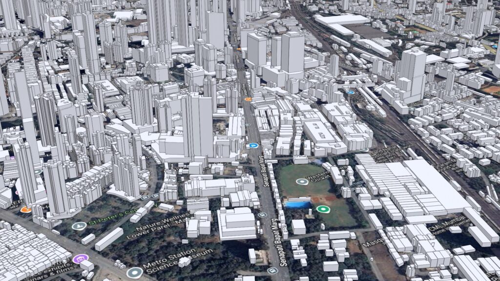
Jio’s goal was to offer Fixed Wireless Access (FWA) based high-speed broadband across India in the shortest time possible. But to achieve this incredible goal, their team needed to overcome a unique combination of scale and precision. If you’re unaware, India spans over 3.28 million square kilometers and includes some of the world’s most varied terrain—from high-rise apartment clusters in Mumbai to dense forests, rivers, and rural villages. The UBR based AirFiber solution required precise line-of-sight (LoS) between tower equipment and customer premises, meaning Jio couldn’t rely solely on traditional RF coverage models and fiber buildouts. Instead, the company needed to build a comprehensive geospatial system to determine signal feasibility down to the individual apartment floor across tens of millions of buildings.

Adding to the complexity, the AirFiber deployment had to happen in under 12 months. With phased tower activations, leveraging both 5G and UBR technologies, the deployment required real-time prioritization based on customer demand, terrain and built environment interference, and signal strength. Traditional systems were not designed to operate at this data volume or spatial complexity. Jio needed a solution that could support billions of spatial calculations, model 3D signal pathways, integrate with their existing OSS/BSS landscape, and ultimately drive real-time business decisions for marketing, sales, and service delivery.
The Solution: Building India’s Digital Infrastructure with GIS
Jio turned to geospatial technology to power every stage of its AirFiber deployment. At the heart of the effort was a national-scale 3D GIS system built on Esri’s ArcGIS platform. What makes ArcGIS a key foundation in this effort, is that it’s capable of ingesting massive datasets, delivering spatial analytics, and enabling real-time visualization and decision-making across departments in near real-time. There are two types of tower activation here i.e. 5G and UBR. The hardware equipment installed on towers are different for both frequencies. However, most of the towers have both 5G as well as UBR equipment installed. That creates options for user (AirFiber and AirFiber Max), for the company to have more capacity at those towers.
So, where does a company begin in an endeavor like this? The first step for the team at Jio was creating a foundational 3D building database. Jio mapped over 100 million buildings across India’s top 900 cities and towns, achieving 98% accuracy with 1–2 meters of precision. The GIS team then incorporated a rich set of spatial layers, including digital surface models, road networks, vegetation, flyovers, and bridges. Using advanced machine learning algorithms developed by their team in-house, they matched new 3D models to existing 2D data records, estimating the number of residential, commercial, and mixed-use units in each structure.
This building-level intelligence became the cornerstone of Jio’s wireless planning. Each structure was further subdivided into 3-meter point meshes to model signal availability at every floor level. This meant every 10-foot by 10-foot section of a building could be evaluated for signal strength and availability, allowing the network team to assess exactly where AirFiber service could be delivered—even before towers were activated.
Next came radio frequency and coverage planning. Jio fed its 3D GIS layers into a third-party RF simulation platform, which used the building geometries, terrain data, and tower locations to produce coverage maps. These maps visually indicated signal strength and quality using color-coded shapes—making it easy to determine which areas had strong signal potential and which needed additional infrastructure.
With coverage maps in hand, the business team needed to prioritize tower activations. Not all 300,000+ towers would go live at once, so Jio used spatial analysis to identify which towers could serve the highest number of viable customer buildings. Once the towers were active, the team analyzed billions of mesh points for signal quality and intersected them with building and customer data. The volume of data the team at Jio was using was staggering, with billions of points being processed and then enriched with signal information. To handle this load, Jio leveraged its in-house big data platform alongside ArcGIS Pro, running over 20,000 concurrent licenses under Esri’s enterprise agreement. This allowed the company to scale processing capabilities without delay and keep pace with the aggressive rollout timeline.
Empowering Every Team with Geospatial Intelligence
Jio didn’t stop at analysis though. They then brought the power of GIS to life through a suite of applications that served everyone from network engineers to sales representatives and customer care technicians. Their entire organization was leveraging location-based resources to take on their daily tasks.
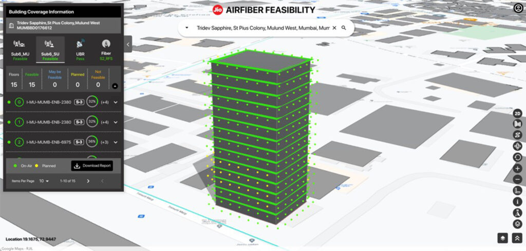
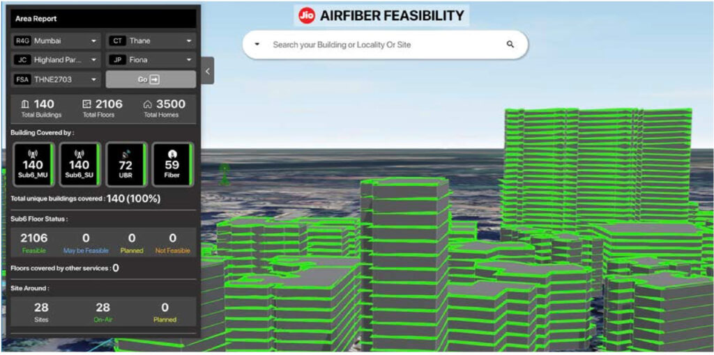
Their flagship resource was a web-based GIS platform designed for interactive visualization of buildings, towers, and signal coverage. Teams could drill down to individual buildings, floors, and even rooms to see whether a location was serviceable via 5G or UBR. Green and blue indicators made it easy to determine full or partial coverage, helping field teams plan equipment installation and sales teams qualify leads.

The team at Jio also built mobile apps for point-of-sale systems, allowing sales teams to verify coverage in real time. For instance, if a customer’s building wasn’t in the system, the app enabled technicians to capture new structure information while on-site—feeding the information back into the GIS for future use. Then, once an order was placed, GIS integrated with Jio’s OSS/BSS systems to streamline work order creation, tower inventory lookup, and logical provisioning.
The impact was transformational. GIS enabled same-day installation for AirFiber in many cases, allowing Jio to serve customers immediately after tower activation. A dedicated GIS app for operations helped network operation center teams monitor issues, resolve service requests, and maintain network performance using a single spatial interface centered around location intelligence.
Extending Coverage with UBR and Line-of-Sight Modeling
Leveraging the advancement in hardware technologies and free availability of radio frequencies, Jio used UBR-based AirFiber deploying high-power wireless equipment on buildings to create line-of-sight links to surrounding structures. To achieve the planning and design needs, Jio developed a highly customized line of sight (LoS) analysis engine within ArcGIS Pro.

The system they developed evaluated antenna tilt, azimuth, beam width, and customer building heights to determine feasible communication paths. Each floor of a building was modeled with 3-meter horizontal and vertical divisions, and every customer point (CP) was assessed against nearby tower sectors. The process also calculated Fresnel zones and evaluated each CP based on signal clarity and distance.
To meet business requirements, Jio needed to assess nationwide coverage scenarios in under a week. This demanded massive compute power, so the team answered by deploying over 200 high-performance servers—each running 50 to 100 concurrent instances of the Jio LoS model. With no GeoAnalytics Server available, Jio leveraged ArcGIS Pro licenses at an unprecedented scale. At its peak, the team was consuming more than 20,000 licenses simultaneously—a feat made possible only through Esri’s enterprise licensing support.
The result was a complete, and predictive, LoS model for UBR deployment published as a web and mobile application for field verification and service planning alike. Incredibly, Jio achieved 92% accuracy in its UBR coverage predictions across India’s urban centers, dramatically accelerating service rollout and increasing customer satisfaction.
A New Model for Broadband Deployment
By combining high-resolution geospatial data, custom analytics, and scalable cloud infrastructure, Jio has created a new model for delivering broadband in the 21st century. AirFiber is more than just a wireless product—it’s a testament to how location intelligence can transform network economics, customer experience, and digital inclusion.

From data preparation to planning, execution, and maintenance, GIS has been the connective foundation of Jio’s AirFiber program. It has unified business units, enabled smarter decisions, and allowed one of the world’s most ambitious telecom rollouts to happen on time and at an incredible scale.
“We at Jio cannot envisage any other system than the one we built at the shortest possible time to support our AirFiber deployment,” said Dr. Biswaketan Kundu, VP and Head of GIS at Jio Platforms. “Super-fast planning and faster deployment helped us disrupt the broadband internet market by positioning AirFiber as a premium and affordable product with same-day installation time. Our continuous investment in GIS data, people, and Esri’s technology helped us build these systems in-house at record speed.”
Looking forward, as Jio continues to evolve its digital platform, GIS will remain at the heart of its strategy—connecting towers to homes, signals to services, and customers to what’s important in their lives.
Resources
Learn more about Jio AirFiber: https://www.jio.com/airfiber/
Esri in Telecommunications: www.esri.com/telecom